During Phase 3 of the Regional Niagara River/ Lake Erie Watershed Management Plan project the Lake Erie Watershed Protection Alliance (LEWPA) hired and trained interns to walk the streams of the Niagara River/Lake Erie Watershed and take observations every 200 feet using a modified Stream Visual Assessment Protocol (SVAP) procedure from NRCS. Five of the 19 sub-watersheds were assessed in this manner by Buffalo Niagara Waterkeeper in Phase 2 of the project. During Phase 3 of the project, the remaining sub-watersheds, with the exception of the Lake Erie Shoreline Sub-watershed (aka Pelee Island Sub-watershed), were assessed by LEWPA (2021-2024). This is because the protocol was designed for streams that could be walked and was not adapted to the Lake Erie coast. In total, 18 sub-watersheds had streams assessed.
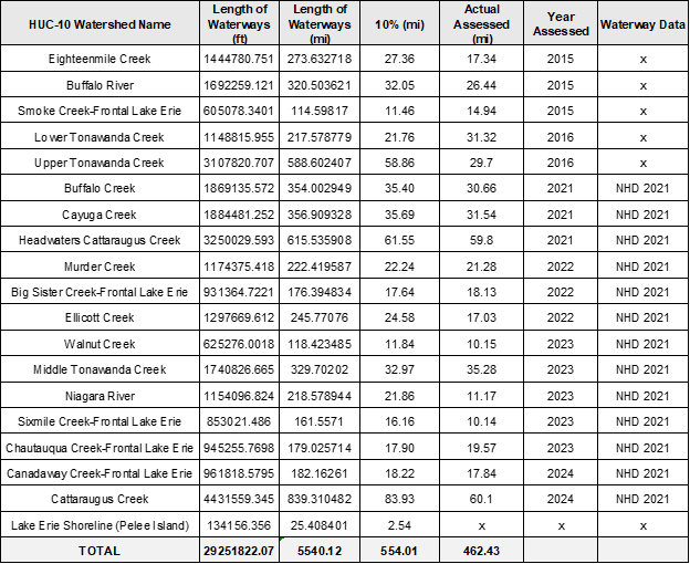
There are approximately 5,540 miles of waterways in the Niagara River/Lake Erie Watershed. The goal was to assess approximately 10% of the waterways (554 miles). In total, 462 miles of waterways were assessed or 8.3%.
Data for each sub-watershed assessed in Phase 3 was visualized to help quickly identify areas with issues or areas in good shape in need of protection. You can access the results for each sub-watershed below.
Big Sister Creek-Frontal Lake Erie Sub-watershed
Canadaway Creek-Frontal Lake Erie Sub-watershed
Cattaraugus Creek Sub-watershed
Chautauqua Creek-Frontal Lake Erie Sub-watershed
Headwaters Cattaraugus Creek Sub-watershed - being edited
Middle Tonawanda Creek Sub-watershed